Mineral Exploration
Can geologists guess where you've been on holiday from the sand in your backpack?
5:46
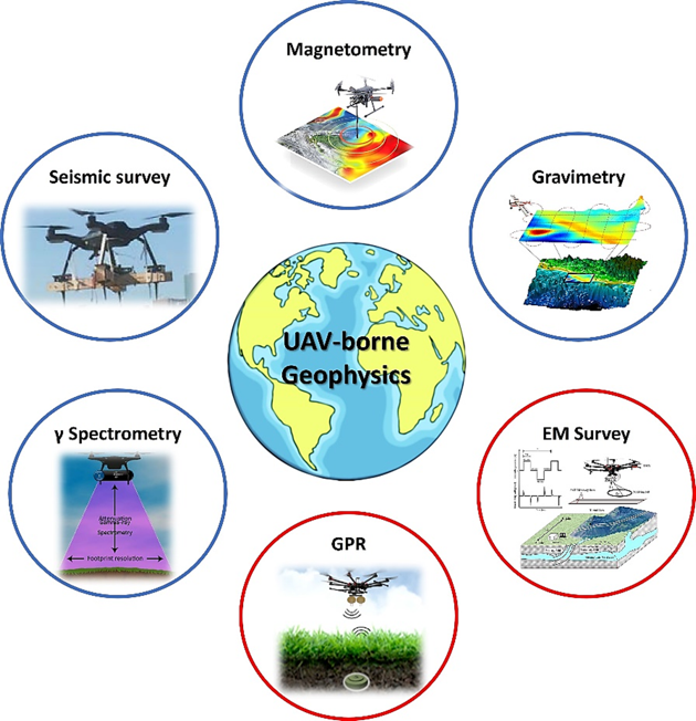
The growing popularity of UAVs and ongoing advancements in UAV-compatible technologies have greatly influenced geophysics. This article is dedicated to the application of UAVs for geophysical surveys with a short review of different available sensors, applications, and processing strategies
UAVs offer benefits ideal for geophysical surveys: they are cost-effective, easy to transport, can operate autonomously, and fly at low altitudes, amongst many other advantages.
This combination makes UAV-based geophysical methods an effective blend of traditional airborne and ground-based techniques, bringing the benefits of both approaches.
UAV-based magnetometry has emerged as a leading-edge remote sensing geophysical technique that is gaining considerable interest among researchers.
This method systematically maps and investigates subsurface structures, specifically focusing on detecting anomalies and spatio-temporal variations in Earth's geomagnetic field. These variations stem from shifting magnetic properties typically linked to subsurface magnetic objects like geological formations.
UAVs equipped with specialised sensors conduct this exploration by flying at low altitudes.
As discussed in this study, one primary challenge in UAV-based magnetometry is the reduction of magnetic interference that can compromise the accuracy of sensor measurements. Addressing this issue is crucial for ensuring the reliability and precision of the collected geophysical data.
UAV-based gravimetry, which involves measuring the Earth's gravitational field from elevated altitudes, has shown significant potential. However, UAV-based gravimetry presents unique challenges compared to magnetometry due to the need for specialised configurations like isolation systems, gimbals, and other specific components. These components must also be miniaturised to be compatible with UAV platforms.
UAVs have also become essential tools for radiation mapping and monitoring, offering solutions to the challenges and hazards associated with environmental radiation exposure in traditional ground and manned aerial surveys.
Gamma-ray surveying has recently gained particular importance among the various radiation mapping methods—such as alpha-ray and beta-ray surveys. UAV-based gamma-ray spectrometry, or radiometry, allows for non-invasive radiation level assessments while minimising human exposure to potentially hazardous environments.

UAV-based seismic surveys represent a distinctive passive method. Unlike remote sensing, this method involves the UAV making physical contact with the Earth's surface via geophones, distinguishing it from other geophysical surveys.
Due to its novelty and limited use in the field, we will not discuss UAV-based seismic surveys further here; readers interested in this approach are encouraged to refer to the studies linked at the end of the article for more information on its methods and applications.
UAV-based EM surveys represent an active geophysical technique for investigating subsurface characteristics. This approach uses various configurations, all revolving around the principle of generating electromagnetic (EM) waves via a transmitter positioned on the ground or carried by a drone. These waves interact with subsurface materials and are then reflected back to a sensor positioned on another drone.
UAV-based EM surveys can operate in time or frequency domains, depending on the survey's specific goals. This adaptable method offers valuable insights into subsurface properties, making it applicable in diverse geophysical contexts.
Ground-penetrating radar (GPR), a well-established geophysical technique, employs radar waves to probe beneath the Earth's surface, revealing hidden structures. Recent advances have fused GPR with UAV technology in a method known as UAV-based GPR, allowing access to remote and difficult terrains.
By sending and receiving high-frequency radar waves, UAV-GPR systems capture radargrams of subsurface features. These radargrams can be processed to create detailed 3D models, enabling exploration of otherwise hard-to-reach subsurface areas and opening new opportunities for subsurface modelling.
To learn more, check out this paper entitled Unmanned Aerial Geophysical Remote Sensing: A Survey
To explore UAV-based seismic surveys, see these studies called A New Buzz in the Air: Seismic Drones and Drones for Deploying Seismic Nodes: For Those Hard to Reach Places