Climate Change
Earth from Space: Smoke Plumes from Chile Wildfires
3 min
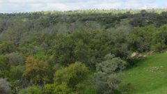
Forests play a vital role in mitigating global warming and preventing biodiversity loss. They cover a third of the Earth, and about 45% are in the tropical zone. Most of our forests are natural, while only a small proportion of forests come from plantations.
Although the rate of deforestation has decreased in the last decade, the percentage of plantations still does not compensate for the forest we lose every day. Furthermore, the percentage of introduced species in the plantations exceeds the number of native ones, changing the composition and structure of the current forest.
Deforestation is not the only problem our forests face today. Various disturbances are affecting the quality of our forests, increasing their degradation and reducing their capacity to provide services and goods.
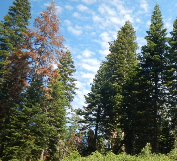
Among the disturbances likely to affect our forests, land use changes, forest fires and insect diseases cause the most significant impact in terms of deforestation and forest degradation. Furthermore, due to climate change, it is expected that we will have more intense and frequent droughts that will exacerbate the decline of our forests around the world.
Reducing and preventing forest degradation caused by environmental changes and human land use is one of the priorities for environmental policies around the world.
For example, the Sustainable Development Goal 15 of the 2030 Agenda for Sustainable Development adopted by the United Nations, one of the most important actions for the conservation and preservation of the Earth's environmental conditions, says, "protect, restore and develop sustainable use of terrestrial ecosystems, to promote sustainable forest management, combat desertification, and halt and reverse land degradation and halt biodiversity loss".
Additionally, one of the objectives of the EU Biodiversity Strategy for 2030 is to restore forests by increasing their quantity and improving their health and resilience, emphasizing the importance of science to achieve this goal.
To prevent or minimize the loss of our forests and restore their quantity and quality, we need continuous and up-to-date mapping and assessment of the condition of our forests to obtain a better overview of their health, as well as to detect changes that are affecting them and the main drivers of change. Accurate and timely information on the state of our forests will help us identify priority areas of intervention and define management plans to protect them.
To understand the current situation of our forests, it is vital to know what these forests were like in the past, what types of disturbances they have suffered and how they have responded to them. This will allow us to predict their future behaviour under different management practices and/or climate change scenarios.
Conventional forest inventories manually measure each tree in the area, which is impossible in large or inaccessible areas. Additionally, it is time-consuming and expensive and is liable to collection errors.
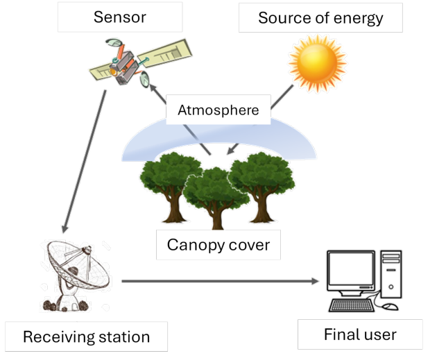
Earth observation data, improved GIS and remote sensing technologies - as well as increasing open source data, open source software and web-based programs - play a vital role in understanding the ecological and biophysical processes of the forests.
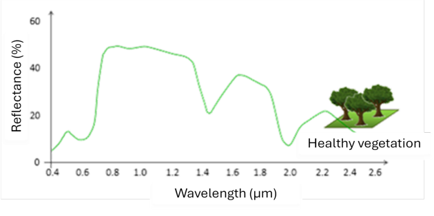
Specifically, remote sensing data's spatial, spectral and temporal resolution allows monitoring and evaluating our forests from local to global scales.
Remote sensing data can cover remote and inaccessible areas. Not only that, it allows us to travel back in time to assess the state of our forests several decades ago.
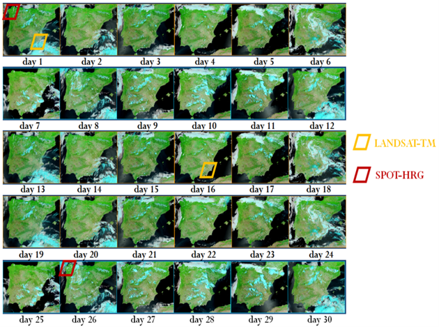
Among the available remote sensing data, multispectral data were the most commonly used for forest monitoring. Landsat time series, in particular, has provided the most consistent and extended series of spatially continuous data since 1972, starting with Landsat 1 ERTS (Earth Resources Technology Satellite), then Landsat 4 and 5 TM (Thematic Mapper), later Landsat 7 ETM (Enhance Thematic Mapper), Landsat 8 OLI/TIRS (Thermal Infrared Sensor) and finally Landsat 9.
Another commonly used remote sensing data for forest monitoring is MODIS (Moderate Resolution Imaging Spectroradiometer), delivered by NASA's Earth Observing System (EOS), which has provided data since the early 2000s. This data was especially useful for regional and global scales, improving the temporal resolution of Landsat data, although the spatial resolution is lower. Sentinel 2 data, although providing shorter time series, is becoming very popular in forest monitoring.
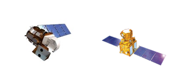
Left: Landsat 8. Right: IRS-P6
The recent and future hyperspectral satellite mission - along with active sensors such as LiDAR and RADAR and the use of Unmanned Aerial Vehicles (UAV) - is opening a new era in forest monitoring.
The combination of different sensors, considering the advantages of each one in terms of their spatial, spectral and temporal resolution, was not yet well implemented for forest morning, allowing accurate information about vegetation structure and composition over time.
Although the lack of long time series with these new data remains a limitation and the challenge of using UAVs in areas such as tropical forests, science is advancing rapidly to improve the use of multispectral, hyperspectral, thermal, RADAR and LiDAR data together for forest monitoring.
In addition to data, we need tools to quantitatively evaluate it to provide useful information for forest management and assist in the decision-making process. Among the existing tools and methodologies for forest monitoring, the statistical analysis of time series (TSA) allows us to quantify, model and forecast the temporal behaviour of a variable based on the history of the variable itself.
The first applications of TSA to model and forecast a variable were made based on the decomposition of time series into trend, seasonality and randomness.
However, in the sixties, Box and Jenings introduced a new concept to model and forecast time series as a stationary stochastic process using the so-called AutoRegressive Integrated Moving Average (ARIMA) models and lately, the Seasonal AutoRegressive Integrated Moving Average (SARIMA) models for time series with very significant seasonal components. ARIMA and SARIMA models have been widely used in economics, although they have been less frequently applied to remote sensing data.
Using these tools for the spatially continuous time series of remote sensing data seems to be a very powerful methodology for environmental monitoring. However, quantifying, modelling, and forecasting temporal patterns using each pixel's history and considering the spatial coherence of this type of data is challenging due to the volume of data used and the complexity of the models. There is still much to do for this methodology to be operational with remote sensing data, especially on a global scale.

The use of TSA with remote sensing data can contribute to a better understanding of the dynamics of our forests and help us develop effective early warning systems to identify priority intervention areas.
This methodology will also allow us to forecast the future behaviors of our forests under various scenarios, being vital information in the decision-making process and developing future policies that can help reverse or minimize forest degradation and preserve our healthy forest.
However, there are still many challenges that remote sensing needs to address in the future.
While the rapid emergence of new technologies for forest monitoring is guiding the future, we still need to improve the dissemination process to facilitate the public's access and use of spatial information. We need better communication between the remote sensing community, ecologists, and forest managers to ensure we are all in the same boat and sailing in the same direction.
Login and start learning!