Digital Twins
Cities are Cloned in the Virtual World to Transform Urban Planning
4 min
A digital twin is a digital replica of a particular physical object, environment and/or event. In the field of geoinformation, the concept was introduced around 2015. In the remote sensing community, it wasn't formalised until 2022. Nonetheless, digital twins are here to stay, especially when it comes to making maps.
The term "twin" can be confusing, as it has different flavours. It can be strict in the sense that identical twins with the same DNA are born at the same time. However, it can also be interpreted more loosely as two things closely related to each other. For example, the phrase "twin cities" generally refers to two cities in different countries that are linked to each other for the purposes of friendship and cultural exchange.
Digital twins are somewhere in between the two interpretations. On one hand, they're far from identical in the sense of material representations, geometric and physical simplifications, origin, age and many other properties that are hard to correctly digitise.
On the other hand, digital twins allow a lot of flexibility in modelling situations. Applications may vary from hyperrealistic visualisations of cities to simulations of extreme events with a series of assumptions and simplifications. What all digital twins have in common is that they should somehow represent an object or event in the real world.
Digital twins require content to function, and this content needs to be generated. In the mapping world, this type of content generation is nothing new.
Common methods for generating digital representations of the Earth's surface from Earth observation data originated in the 1960s. Parallel with the advancements in computing power and image resolution, software for producing digital maps became more powerful as well.
Processing data into 2D or 3D geoinformation has always required taking into account different user requirements and data properties. This is equally important when it comes to generating information for digital twins. Digital twins may have multiple users, and the addition of information from different sources to a digital twin is likely to change the properties of the data it holds.
Digital twinning in mapping has gained momentum due to recent developments in other fields, specifically deep learning and UAV (drone) technology.
Deep learning algorithms in images and point clouds have boosted the quality of semantic segmentation of datasets, making it easier and faster to extract 2D and 3D information automatically.
Conversely, digital twins can help generate realistic training data for better performance in deep learning networks.
UAVs (unmanned aerial vehicles) can capture high-resolution images and point clouds at a local scale to enhance 3D city models.
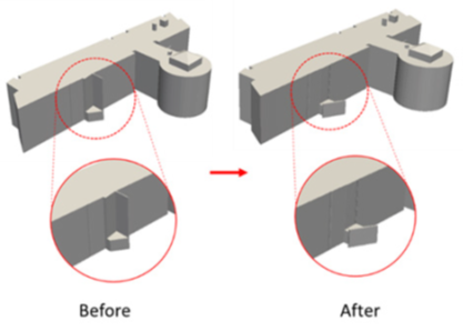
First, outdated or incorrect parts in 3D building models are detected. In the next step, a flight plan is calculated to capture the images required for generating 3D point clouds that can serve to correct the models.
The flexibility in time and space is what makes UAVs so interesting for digital twins; they can add dynamics and recent information to the more static city models.

Improvement of 3D building models after local UAV image acquisition.
The production of content for digital twins at the city scale presents several interesting challenges and questions. After all, creating a digital twin requires input that represents the living city in a digital model.
For ITC at the University of Twente, the rise of digital twins has been an incentive to increase efforts in producing and using 3D models, with the aim of intensifying collaborations with external partners in this field. Many of these efforts involve both education and research. For instance, in cooperation with Dr Florent Poux, courses and Python tutorials were designed for students with different scholarly backgrounds, e.g., geoinformatics and urban planning. ITC researchers look forward to collaborating with colleagues on projects and proposals in the field of generating content for digital twins.
Header picture: AccuCities, CC BY-SA 4.0, via Wikimedia Commons