Food Security
Is this the farm of tomorrow?
5 min
Smallholder farmers in Ethiopia's highlands face weather-related risks, particularly drought. To help them cope, ITC initiated GIACIS (Geodata for Innovative Agricultural Credit Insurance Schemes), a partnership with Ethiopian organisations in agricultural technology, meteorological information, and credit and insurance.
Weather-related perils such as drought disproportionately affect smallholder farmers. Apart from the impacts on production in the current season, these farmers may be unable to reinvest in agriculture in the subsequent season as a drought can wipe out their savings.
Another major consequences of experiencing drought is that farmers try to avoid risk; they become hesitant to invest in inputs and other technologies that can increase their productivity.
Not investing in better inputs and technologies keeps many smallholder farmers in a cycle of low agricultural productivity and its effects on socioeconomic outcomes such as poverty and health.
Geodata-based insurance developed through the Geodata for Agriculture and Water (G4AW) program helps smallholder farmers deal with this challenge. The G4AW is a program of the Netherlands Space Office (NSO) and the Dutch Ministry of Foreign Affairs (MoFa).
A well-designed crop insurance scheme can help deal with both the impacts of drought on production and the mentality of smallholder farmers. Apart from the risk reduction mentioned above, such a scheme does three things:
(i) protects farmers against their potential inability to repay credit for inputs,
(ii) increases smallholder access to finance to invest in better agricultural technologies, and
(iii) remedies the fear of farmers to use more and better inputs for higher productivity.
However, traditional actuarial-based insurance products require long time series data (typically >30 years) on production and other indicators. This data is not typically available in many areas with smallholder farmers where droughts occur.
Working with business, corporate, government, and support partners in Ethiopia and Europe, a team at ITC developed the VICI product.
GIACIS is a single-peril drought insurance product based on quantifying the deviation of a season of remotely-sensed vegetation condition from the expected long-term average as a trigger of premium.
The design is based on a toolbox which calculates a greenness indicator called the Normalised Difference Vegetation Index (NDVI). It uses NDVI data from the Copernicus earth observation programme, which is shared through the EUMETCast delivery mechanism. This data is based on the Sentinel-3 satellite's Ocean and Land Colour Instrument (OLCI) and is updated every 10 days.
NDVI is a common reference measurement for “greenness” as influenced by the amount of active chlorophyll in plants seen through sensors. This greenness responds to drought and is, therefore, a reliable indicator of plant conditions across space and time. With the same sensor data and processing routines, past NDVI measurements can be used to interpret new NDVI measurements as an expected NDVI is set, with any deviation from that being an anomaly.
The GIACIS insurance product is calibrated using past NDVI data to determine the thresholds that are indicative of a drought and its severity. These thresholds can then be applied to new NDVI data to determine if, when and where a drought has occurred and if the severity is sufficient to trigger a payout for insured farmers in that area.
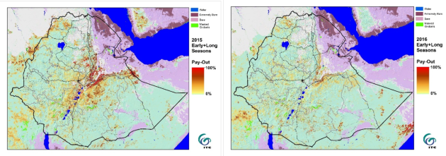
With this scheme, insurance pay-out starts once the NDVI-value drops below the preset trigger value (15%-value) for a 1km2 pixel and is 100% if it drops below the preset exit value (5%-value).
Droughts are extreme events requiring information at the tail end of the distribution. Therefore, the NDVI thresholds need to be based on population statistics instead of sample statistics, which is done in GIACIS.

Figure X: Example output from GIACIS showing areas exposed to agronomic drought and where output was required in (a) 2015 and (b) 2016.
Insurance, particularly crop insurance products, is complex. The following are key unique features of GIACIS as a crop insurance product that make it suited for smallholder agriculture:
To learn more, check out our other article on Impact and lessons learned from the GIACIS project