Digital Twins
Cities are Cloned in the Virtual World to Transform Urban Planning
4 min
Digital twin (DT) technlogy has proven to be powerful in addressing the Urban Heat Island effect and promoting climate-resilient cities.
As urban areas continue to expand, the Urban Heat Island (UHI) effect presents a significant threat to the health and well-being of city residents.
The phenomenon occurs when cities become notably warmer than their surrounding rural areas due to factors such as human activities, dense construction, and a lack of green spaces. The UHI effect contributes to increased energy consumption, deteriorating air quality, and various adverse health impacts.
With an estimated two-thirds of the global population expected to live in cities by 2050, addressing the challenges posed by UHI is essential for creating more liveable and climate-resilient urban environments.
One promising solution for mitigating the UHI effect is using Digital twins. These advanced digital models enable urban planners to simulate various strategies for reducing urban temperatures.
Planners can make informed, data-driven decisions before implementing real-world changes by experimenting with different approaches – such as incorporating green spaces, changing building materials, or redesigning streets.
DTs offer valuable insights into how urban design interacts with environmental circumstances.
Digital twins are using as a basis for 2D or 3D city models combined with environmental simulations. By integrating geospatial data, including LiDAR and satellite imagery, planners can develop detailed models that predict how different urban forms influence temperature distribution.
These models allow for the visualisation of critical factors such as solar radiation and wind patterns, making DTs powerful tools for forecasting the outcomes of planning decisions and optimising strategies for enhanced urban cooling.
Research has already demonstrated the effectiveness of DTs in urban planning. 3D visualisations provided by DT-based models enable planners to observe how various elements – such as buildings, streets, and green spaces – interact. This understanding helps identify ways to trap heat or improve airflow, which ultimately contributes to the cooling of urban areas.
Digital twins also play a crucial role in engaging the public in the urban planning process. Interactive models allow community members to visualise how proposed changes could impact their neighbourhoods. Allowing residents to provide feedback ensures that planning decisions align with their needs and concerns.
Despite their potential, integrating DTs into urban planning is not without challenges. Data quality, real-time sensor integration, and the costs of maintaining DT systems can be substantial barriers.
Moreover, DTs require a consistent influx of reliable data, which can be hard to gather across large urban environments. However, as technology evolves and cities adopt Digital twin systems, these challenges may become increasingly manageable.
Researchers at ITC (University of Twente) were involved in case studies in the cities of Enschede (the Netherlands) and Wuppertal (Germany) to investigate how Digital twins can help to reduce the UHI effect in real life.
• Enschede
The UHI experienced by Enschede is mainly caused by ongoing urbanisation and increasing numbers of impervious surfaces. To address this issue, local city planners use a digital twin system created in collaboration with the University of Twente and uses only open-source software and methodologies.
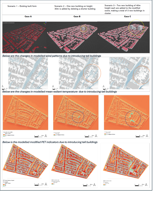
As part of the project, a 3D model was built to simulate and visualise how changes in the built environment affect thermal comfort. The team calculated thermal comfort patterns for the existing urban layout by analysing data from equinoxes and solstices.
They then modified the 3D environment to test the impact of adding tall buildings and removing smaller ones, assessing how these changes create hot and cool zones. Until now, the system has used global weather datasets for the simulations and visualisations. The team aims to replace these datasets with real-time sensor data for improved accuracy.
 Enschede: developed 3D built-form scenarios with visualisation of the changes in modelled wind, temperature and PET (physiological equivalent temperature – a measure that combines air temperature, humidity, and wind speed to assess how the environment feels to the human body). Source: https://doi.org/10.5194/isprs-archives-XLVIII-4-W11-2024-137-2024
• Wuppertal
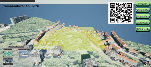
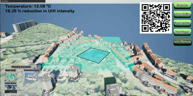
Wuppertal faces significant UHI challenges due to its topography and dense urban fabric, which trap heat, especially in lower areas along the river Wupper. To address these challenges, a Digital Twin-based Planning Support System (DT-PSS) was developed to simulate the impact of various urban planning scenarios on UHI formation.
The DT-PSS combines machine learning, 3D city modelling, real-time temperature data, and scenario evaluations to create an innovative simulation platform to predict UHI effects. The model continuously updates with temperature data from ground sensors, allowing for dynamic simulations based on different planning scenarios.

Wuppertal, current situation: without a water body, the temperature is 15.32 °C. Source: https://www.youtube.com/watch?v=n_TXYSCh74U

Wuppertal, future planning scenario: with a water body, the temperature is 13.08 °C, with UHI intensity reduced by about 18.26%. Source: https://www.youtube.com/watch?v=n_TXYSCh74U
To ensure practical applicability, the Wuppertal system was designed with input from urban planners and municipal officials. A workshop was conducted where stakeholders used virtual reality glasses to interact with the model, explore "what-if" scenarios, and provide feedback on the system's usability and relevance.
To make things even more accessible, a rough mobile version of the DT-PSS was developed. It enables urban planners and citizens to engage actively in the planning process. The tool's intuitive interface allows residents to visualise how urban development may impact their neighbourhoods. Overall, the mobile DT-PSS has been found to enhance public engagement, making urban planning more inclusive and responsive to the community's needs.