Remote Sensing
How NASA ARSET can get you started with satellite data
5 min


Satellite data can be overwhelming, and figuring out which data to use for a specific job can be difficult. It can be even more difficult to download and effectively use the data once you have found it.
This was reason enough for NASA to create a training program called the Applied Remote Sensing Training Program, or ARSET.
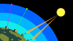
Remote sensing is collecting information about an object without direct contact with it- something satellites do to observe the Earth all the time! You can explore remote sensing on Geoversity.
ARSET has trained more than 140,000 participants from more than 185 countries since its creation in 2009. The program provides training in the use of remote sensing observations for Agriculture, Health & Air Quality, Water Resources, Ecological Conservation, Disasters, Wildland Fires, and Climate & Resilience applications and offers these trainings online and in-person at no cost.
These trainings are application-based, replicable, open-source, level-specific, and are offered in multiple formats. Let’s talk a little more about each of these attributes.
Each ARSET training is designed to teach you how to use NASA satellite data for a specific application. This way, you get a much more in-depth understanding of a specific dataset or set of datasets because you see it being used in a particular situation.
For example, in an ARSET training on using Synthetic Aperture Radar (SAR) data to address flooding, you would first learn what data is available that is suitable for this purpose, how to select an appropriate dataset, then how to download it, which tools or software you could use to make the job easier, and how to put it all together to map floods.
We aspire to make each ARSET training replicable, meaning that whatever you are shown, you can replicate on your own. To ensure this, each ARSET training session is recorded and uploaded to our YouTube channel so you can go back and watch it again.
The presentation slides and other materials are also uploaded on our website so you can access them on-demand. In addition, there is a homework assignment and live, instructor-led Q&A session at the end of each training to help with your understanding of the material.
Another way we make sure you can replicate what you learn is by ensuring that everything is open-source. NASA Earth-observing satellite data is taxpayer-funded, free, and open to the public worldwide.
In addition, we only teach using software and tools that are free and open to the public as well. That way, you can also do everything you see us doing on screen at no cost. The only expense required on your part is a computer and an internet connection.
We understand that not everyone is coming into remote sensing with the same foundation of knowledge. For this reason, we offer training for all experience levels, from those being introduced to remote sensing for the first time to experts who work with the data every day and want to learn about a new sensor or application.
If you have little or no experience with remote sensing, you should start with our Fundamentals of Remote Sensing online course to get you started.
Our training materials are offered in multiple formats to ensure you can access them when needed. As mentioned, each live training session is recorded and uploaded to YouTube, then posted to the training webpage. Even if you can't attend a live training, you can review the recording and access the materials at your leisure.
Aside from our typical live, instructor-led training, we also have other training formats. Just last year in 2024, we launched our first interactive, self-paced, on-demand training, and we plan to launch more in the near future.
We also offer many bilingual trainings, with many offered in Spanish and some in French to improve accessibility of our training materials.
If you would like to try ARSET training for yourself, now is the perfect time. We have a live, instructor-led training coming up on March 25th, The Application of Earth Observations for Assessing Waterborne Disease Risk.
Every year, waterborne diseases such as cholera are responsible for approximately one million deaths, the majority of which are children under the age of five. Some indications of waterborne disease being present can be seen from space, such as water temperature, sediment or suspended solids in the water, and phytoplankton.
This two-part training will focus on describing and accessing remote sensing observations useful as water quality indicators of waterborne diseases and will present case studies where remote sensing data are used to assess the likelihood of cholera outbreaks.
You can register on the training page using the link above.
If this doesn't interest you, if you are looking for something specific, or just want to see the other types of training we offer, you can browse our online training catalogue.
You can also learn about ARSET and sign up for our mailing list for new training updates on our home page. We hope to see you online in our next training session!