


Land Administration Systems
Why managing land reform problems works better than trying to solve them
6 min
Land is an extremely important resource globally. Land administration and management are therefore crucial in meeting many of the requirements of the United Nations 2030 sustainability agenda as outlined in the sustainable development goals (SDGs).
However, in many of the world's countries, land administration tends to be fraught with issues and barriers hindering its effectiveness.
Kenya is a case in point. The country is very much in need of efficient land data exchange and interoperability.
In the current situation, discrepancies and errors are rampant due to organisational, technological and conceptual problems. Different organisations and departments dealing with land administration and land management don't have a framework for sharing the data they produce with other stakeholders. Data is often siloed in different locations, and access constraints and data duplications are the order of the day.
To address these issues, Kenya is now developing a digital land information management system called Ardhisasa. Serious efforts have been made already, but there's still a lot of work to be done.
Conversion of land data from analogue to digital is ongoing, and as yet, the system only offers basic cadastral information that isn't linked with registry data.
Against this backdrop, researchers decided to create a specific Kenyan land administration data exchange and interoperability framework that addresses concerns, removes barriers and selects the most fitting approach for implementation.
The framework aims to support data acquisition, land transactions and distribution of land data.
To this end, a Land Administration Domain Model (LADM) profile for Kenya was first developed as a base. It incorporates data from both land registry and cadastre while keeping organisational mandates intact and allowing for the access of other land administration actors as well.
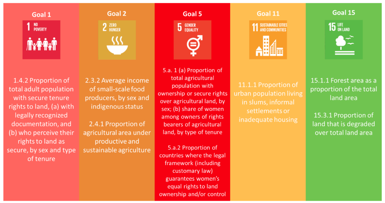
Mapping land resources, their ownership, utilisation, value and protection is essential when it comes to tracking and monitoring the attainment of the SDGs.
In this context, country-specific issues in terms of people-to-land relationships deserve extra attention. Promoting certain groups in society can help to reduce poverty, hunger and diseases.
This is why, during the development of the Kenyan LADM profile, four issues specific to Kenya were identified and modelled:
• gender recordation and rights
• community land and rights
• pastoralist rights
• informal occupation and rights
These four unique issues were found to map seamlessly with the various SDGs.
A recent study undertaken as part of this research describes a method for implementing and testing the newly developed LADM profile and ensuring a complete and accurate workflow.
The study involves field testing, with the developed model being put to use by stakeholders.
In preparation of this, all land administration data sources were first identified and an interoperability framework was developed following the guidelines outlined in the ISO Framework for Enterprise Interoperability (FEI).
Kenya's specific LADM issues were mapped to the SDGs, and the LADM profile was refined drawing on previous tests in Kenya and Colombia. The profile was then converted to a desktop GIS software DBMS (database management system) to make it ready for implementation and use.
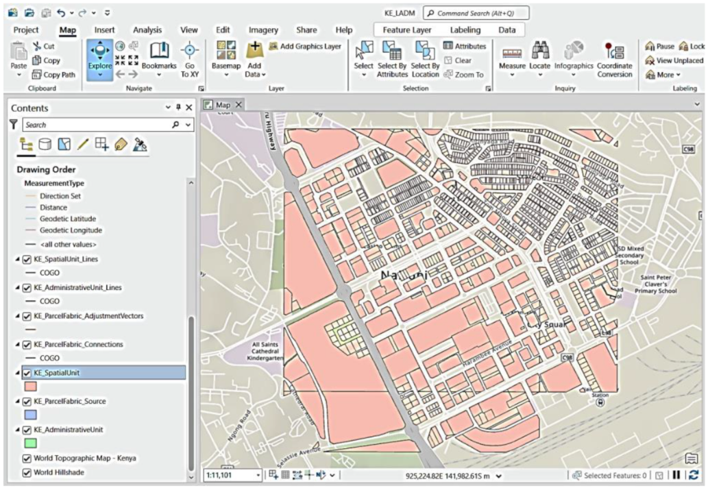
In the next phase of development, existing digital parcel data was migrated and entered into the database, and a web application was developed to enable information sharing and collaboration on a large scale.
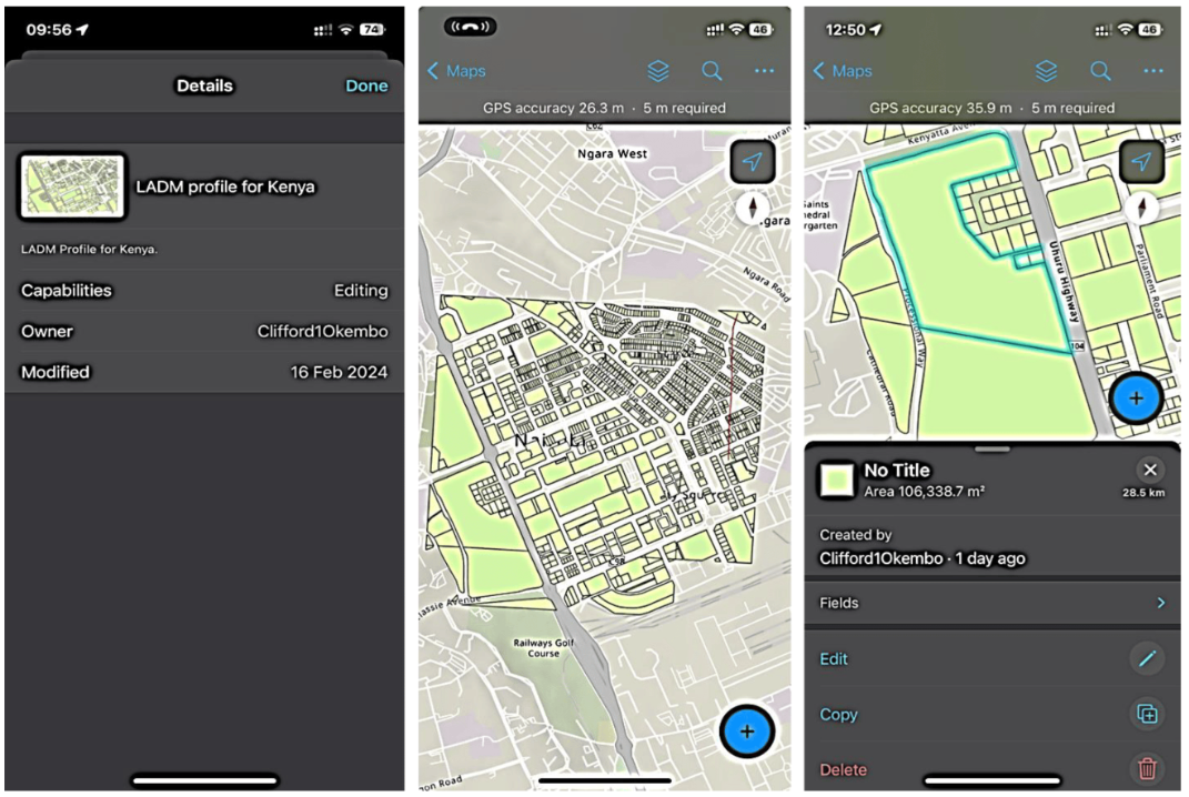
For collecting field data to complement the existing data, the Field Maps app used successfully in the previous tests was configured to match the Kenyan LADM profile.
In the final step, a team carried out actual test mapping in the field using the app.
For land data exchange and interoperability to be effective, it's essential to identify who generates what data and who needs it. Besides promoting efficiency, this prevents the creation of redundant data and reduces cost. The researchers conclude that their developed framework can play a pivotal role here.
The framework also demonstrates that integrating cadastral and registry data is achievable. It is expected that the framework can be applied in other countries as well, as long as country-specific factors are taken into consideration.
All in all, the researchers surmise that their framework supports Kenya's progress toward sustainable development.
The researchers note that collaboration and centralised management are crucial for land administration to be truly effective. Maximum integration with external systems is recommended to facilitate data integrity and avoid duplication.
To enable the necessary finetuning of the land administration data interoperability framework, the researchers recommend a pilot implementation, e.g., in one or several Kenyan counties, before a national rollout.
The researchers fear that data owners may not be willing to share or provide data that could be accessible to others. To address this issue, they recommend sensitisation or training in workshops and conferences, along with a comprehensive change management programme.
In terms of achieving SDGs, the researchers stress the importance of land information, as secure tenure enables citizens to achieve sustainability goals.
Success here can be enhanced by involving land rights holders in fieldwork as much as possible and generally promoting broader stakeholder engagement when implementing and applying the framework.
Header image: Janetnyanya, CC BY-SA 4.0 , via Wikimedia Commons
This story is an adaptation of a journal article: Okembo, C., Morales, J., Lemmen, C., Zevenbergen, J., & Kuria, D. (2024). A Land Administration Data Exchange and Interoperability Framework for Kenya and Its Significance to the Sustainable Development Goals. Land, 13(4), 435. It has been adapted with permission from the authors and in accordance with the copyright license CC BY 4.0
To view the original article, see the link below:
Login and start learning!

