Remote Sensing
Earth from Space: Pariacaca Mountain Range, Peru
3 min
Location data is crucial for assessing whether taxpayers’ money improves the lives of citizens. In this article, we’ll explain why and how it’s used.
Egbert Jongsma; Wietske Bijker
Our national, regional, and local governments collect taxes to safeguard and improve the daily lives of citizens. They provide the roads and public transport we use; the education to develop and grow our potential; the health and security systems that keep us safe, and so much more.
Public spending should therefore be wise and follow the rules and regulations.
It should also be efficient and not be wasted.
And it should be effective and add value to the daily lives of citizens.
Lastly, public spending should be agreed on by citizens and taxpayers, as represented in parliament.
Supreme Audit Institutions are tasked with assessing whether or not the spending of public funds by the national government is being done wisely. These institutions enhance the ability of parliament to scrutinize the government and hold it accountable.
Public spending can be seen as a geospatial movement from source (government) to destination (citizens). All public spending is therefore geospatial spending.
Geospatial information provides an essential link between government officials drafting policy solutions and citizens who should benefit from these solutions. The government should use geospatial information to determine what is needed, by whom, and where.
At the same time, the government should use geospatial information to demonstrate the results they have achieved with the public funds invested, as part of their accountability to parliament and citizens.
If public spending is geospatial spending, then what's needed is geospatial auditing. Auditors should be aware that geospatial information plays a crucial role in assessing whether public funds are spent wisely.
In order to make this assessment, they need to ask key questions:
- Are public funds targeted to locations with the highest needs?
- What results are achieved in locations selected for government spending?
- Are those results better than in locations where the government didn't spend public funds?
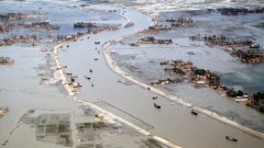
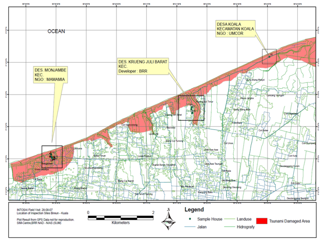
In the aftermath of the Boxing Day Tsunami of 2004, which also affected Sumatra, Indonesia, new housing projects were needed. For those housing projects near the coastline, a minimum distance of two kilometres was set by the Indonesian government. This was for safety reasons - in case a tsunami struck the coast of Sumatra again.
With billions of US dollars in national and international aid coming to the affected countries, it was necessary to ensure that the money was spent wisely.
Together with the Rehabilitation and Reconstruction Agency of the Indonesian government (BRR) and ITC, a task force of the International Organization of Supreme Audit Institutions (INTOSAI) used geospatial information to assess whether new housing projects kept to this distance.
The results are shown in the following map:
"I have to change to stay the same".
This was the motto of the artist Willem de Kooning, and it's one that Supreme Audit Institutions have to live by.
Nowadays, many Supreme Audit Institutions around the world do this by using scientific and business innovations in their own field, like data analytics, and design thinking and by directly engaging with businesses and citizens.
Supreme Audit Institutions also make more and better use of geospatial information in their audit process. By innovating their methods, techniques and data sources, they can cope with societal developments and stay relevant, with an ability to make an impact on government functioning and performance.
To further develop geospatial auditing, the assistance of the geospatial community is needed. The Netherlands Court of Audit, the Supreme Audit Institution of the Netherlands therefore has a longstanding cooperation and knowledge sharing with ITC, the University of Twente's Faculty of Geo-Information Science and Earth Observation.
Login and start learning!