Artificial Intelligence
Deep Learning with Real-time Flood Inundation Maps
3 min


Glacier monitoring in alpine regions is crucial for understanding how glaciers respond to climate change, how they impact water resources and ecosystems, and their role in natural hazards.
A recent study tested a novel monitoring approach using a low-cost camera system.
Traditional glacier monitoring methods like satellite imaging provide broad coverage but lack the detail needed for studying smaller glaciers over shorter periods.
UAV (aka drone) photogrammetry offers detailed 3D reconstructions at low cost but requires significant on-site effort, making frequent monitoring impractical.
Ground-based methods like terrestrial SAR (synthetic aperture radar) and TLS (terrestrial laser scanners) are precise but expensive and logistically complex, limiting regional applications.
Time-lapse cameras present a more practical and affordable alternative to the above. They can estimate glacier movement using digital image correlation (DIC).
Earlier research mainly focused on single-camera setups or systems with a small baseline (distance between cameras), but they have serious limitations.
The recent study tests a low-cost stereo-camera system with a wide baseline. The researchers used 3D reconstruction from these stereo cameras for volume estimation and DIC on monoscopic images to derive surface velocities.
By utilising state-of-the-art deep learning (DL) matching techniques for 3D reconstruction under suboptimal viewing conditions, this approach overcomes the challenges posed by the wide camera baseline.
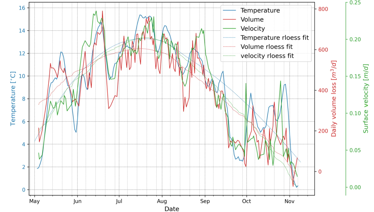
The system measures daily surface movement, ice loss, and glacier retreat while exploring links between temperature, ice volume changes, and surface velocity.
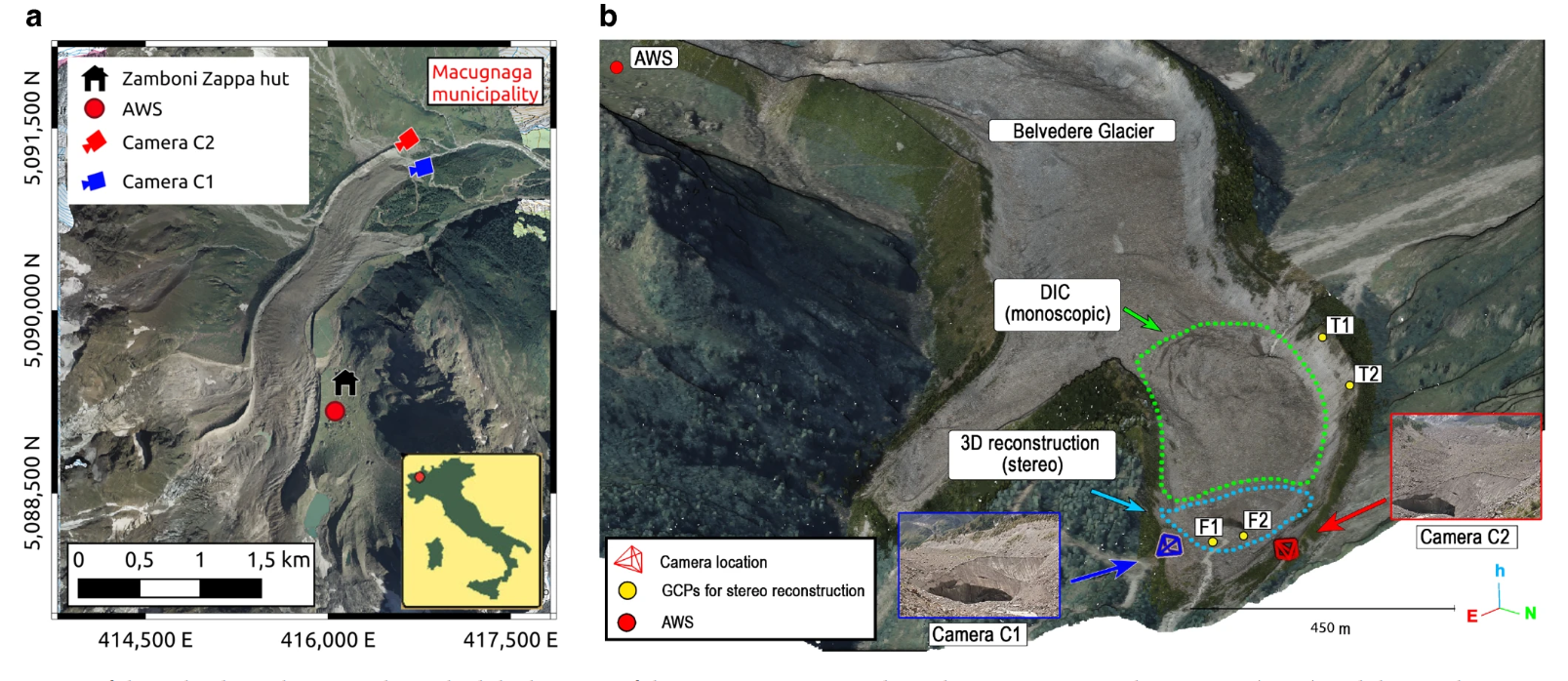
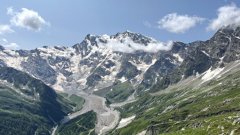
The Italian Belvedere Glacier is located in Valle Anzasca, Italy, on Monte Rosa’s east side. Its lower part is a temperate, debris-covered glacier spanning 1.8 square kilometres. It lies at 2,250 –1,800 metres above sea level and splits into two lobes. The northern lobe ends in a steep ice cliff, feeding the River Anza. This lobe is rapidly melting, retreating by 20 meters annually due to ice collapses.
The researchers selected this lobe for testing due to its highly dynamic changes.
In 2021, the researchers installed two cameras on tripods near the northern tongue of Belvedere Glacier: C1 at 230 metres from the ice cliff, capturing the ice cliff itself, and C2 at 350 metres, observing the glacier surface. The cameras' 261-meter baseline provided good parallax, although causing some distortions and occlusions.
The monitoring stations operated from August 2021 to December 2022. During the snow-free study period (1 May 2022 to 13 November 2022), both cameras were able to acquire images every day, for a total of 197 images.
However, 39 images were discarded due to bad weather conditions, such as rain, low clouds, or fog, resulting in 158 days of valid data for stereo and monoscopic processing.
In the summer of 2022, two UAV flights, spaced by a 10-day interval, were conducted to acquire the necessary ground-truth data.
During the first flight, the UAV captured 436 images with an average ground sample distance (GSD) of 3 centimetres. Additionally, 19 ground control (GCPs) were measured, including both artificial targets and natural features.
The second UAV flight focussed on a smaller portion of the northern lobe of the Belvedere Glacier. It captured 428 images, again with an average GSD of 3 centimetres.
To analyse the correlation between the Belvedere Glacier dynamics and external environmental variables, the researchers used data measured from a nearby automatic weather station (AWS). This data concerned air temperature, precipitation, and incoming solar radiation.
The daily images captured by C1 and C2 were processed using two parallel approaches:
• Photogrammetric stereoscopic approach: pairs of daily images were used to create 3D models of the glacier terminus, allowing the calculation of ice volume loss by comparing point clouds along the glacier's main flow direction. This approach focused mainly on reconstructing the 3D structure of the terminal ice cliff.
• DIC-based monoscopic approach: images from camera C2, which provided a higher viewpoint with broader coverage, were used to estimate the surface velocity over a larger area of the glacier. This approach compensated for the stereoscopic method's limitations in generating a full 3D surface velocity field for the glacier.
The wide baseline between the two cameras created difficulties for traditional hand-crafted feature matching techniques. They could not identify enough corresponding points to estimate camera poses.
Deep learning-based matching algorithms, however, performed significantly better. Their high success rate enabled the estimation of a sparse yet complete 3D reconstruction of the terminal ice cliff, which served as the foundation for a more detailed scene reconstruction.
This approach overcomes the challenges posed by the wide camera baselines and allows for more accurate 3D reconstruction under suboptimal viewing conditions.
The principal aim of the study was to develop a low-cost stereoscopic system that's able to derive daily 3D reconstruction in a complex environment.
For this reason, the researchers focused on the frontal part of the glacier, which presents the worst conditions due to the fast ice melting and related morphological variations.
The developed system proved effective even under these complex conditions, which suggests that it should be easily adaptable to other, less challenging sectors of the glacier.
As to the transferability of the system, the installation process is relatively straightforward. The cameras are mounted on topographic tripods, which eliminates the need for complex and permanent structures. This allows for the system to be replicated at different sites without too much trouble and cost.
The researchers conclude that their approach enables accurate estimation of glacier dynamics, including surface movement and terminus ice volume loss and retreat.
One of the key findings of the study was the significant correlation observed between air temperature and glacier surface velocity and ablation.
The system could be improved by adding more cameras to expand the study area. This would provide a broader coverage of glacier dynamics, and enhance the accuracy of the monitoring system.
The overall conclusion is that this innovative approach enhances understanding of glacier behaviour in a warming climate.
Header image: Tiia Monto, CC BY 4.0, via Wikimedia Commons
This story is an adaptation of a journal article: Ioli, F., Dematteis, N., Giordan, D., Nex, F., & Pinto, L. (2024). Deep Learning Low-cost Photogrammetry for 4D Short-term Glacier Dynamics Monitoring. PFG–Journal of Photogrammetry, Remote Sensing and Geoinformation Science, 92(6), 657-678. It has been adapted with permission from the authors and in accordance with the copyright license CC BY 4.0
To view the original article, follow the link below:
Login and start learning!