Planning Support Systems
The EquiCity Game: Promoting fair decision-making in urban planning
6 min
In collaborative spatial planning, maptables are increasingly popular. However, software applications specifically designed for maptables are still scarce. Applications that are often used tend to have important setbacks. Researchers developed and evaluated an open-source platform to address this gap.
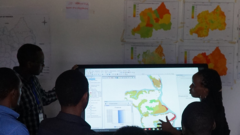
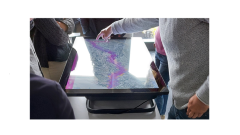
Maptables are increasingly used to support stakeholder participation in planning support system (PSS) workshops. A maptable is a large horizontal surface that shows geospatial content and enables user groups to interact with the displayed content via touch gestures.
Still, specific software is limited and frequently used applications are often designed for vertical screens or involving interaction with a mouse and keyboard.
Since this limits the usability of maptables as PSS tools, researchers set out to develop a specific software application and test its usability in a maptable-based workshop setting. The software was named OGITO (Open Geospatial Interactive Tool).
Usability can impact how users perceive the added value when using PSS tools. Low usability can also stand in the way of the participation of marginalized groups.
In order to properly evaluate the tool they were developing, the researchers adopted the usability framework of ISO (the International Standard Organization). In the ISO framework, usability is defined as the extent to which users can achieve their tasks with effectiveness, efficiency and satisfaction.
The researchers chose a human-centred design (HCD) approach to their software development process. In HCD, the intended users are given a pivotal role and user feedback is used to refine aspects of the process. This approach was combined with Agile software development principles aimed at quickly delivering software that satisfies customer needs.
Based on recent developments in computer science research, the researchers surmised that combining HCD and Agile could be a way to produce a highly usable interactive software tool within a short timeframe.
The selection of OGITO's application platform was based on four reported and verified user needs:
- support for touch gestures (e.g., pinch, pan, rotate)
- simple and mobile-oriented GUI (graphical user interface)
- open-source
- integration with other tools in the geospatial ecosystem.
Based on the above, OGITO was built on widely accepted and well-tested components already available in the current geospatial software ecosystem.
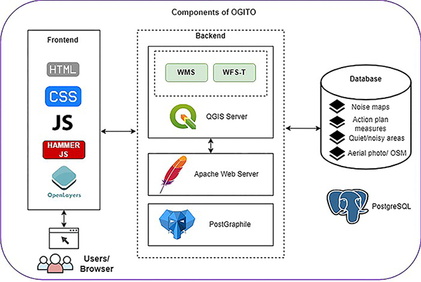
Image: Aguilar et al. (2021)
A web platform was selected so that the application could also be used remotely, enabling a broader audience to participate.
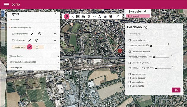
OGITO provides an interactive map, layer management, data input and sketching. All functions are available via touch, so no mouse or keyboard is required. Minimalistic design makes sure that users are given just the tools they need for the job at hand.
A case study in community mapping in Sumatra, Indonesia provided the context for a formal usability evaluation of OGITO. The tool was tested with users in PSS workshops, with usability being assessed as the extent to which a user group could produce a participatory map of their village in a maptable-based PSS. Through iterative development cycles and feedback from users, the tool evolved until it satisfied user expectations.
Post-workshop questionnaires showed that case study participants were generally enthusiastic about OGITO's usability in terms of effectiveness, efficiency, and satisfaction.
The researchers conclude that OGITO was well-received by workshop participants who had never used a maptable before. They surmise that this favourable result was obtained by combining HCD and Agile principles, hence, creating an iterative development process with a high level of user involvement. Frequent review meetings and user feedback shaped OGITO into a lightweight application with a simple interface that provides the required functionality.
On top of that, the accompanying study contributes to the broader literature by reporting a usability framework for the development of PSS applications.
This story is an adaption of a journal article: Aguilar, R., Calisto, L., Flacke, J., Akbar, A., & Pfeffer, K. (2021). OGITO, an Open Geospatial Interactive Tool to support collaborative spatial planning with a maptable. Computers, Environment and Urban Systems, 86, 101591. It has been adapted in accordance with the copyright license CC BY 4.0.
Follow the link below to read the original article:
Login and start learning!