Geohealth
A novel spatiotemporal approach to COVID-19 surveillance
4 min


In November 2023, the ITC Faculty at the University of Twente hosted the 16th symposium of the global network of public health and earth scientists dedicated to the development of geospatial health (GnosisGIS).
Geospatial health is an interdisciplinary field that integrates geographic information and spatial analysis with health research to study the relationships between environmental, social, and geographic factors and health outcomes.
It leverages tools like Geographic Information Systems (GIS), remote sensing, and spatial statistics to map disease patterns, track infectious diseases, assess healthcare access, and analyse the impact of environmental and climatic conditions on public health, to inform better health decision-making and interventions.
During the GnosisGIS symposium, a multidisciplinary group of researchers from across the globe discussed achievements, innovations, and priorities in this field.
In this Geoversity story, we'll summarise the symposium's main findings.
Over the past decade, geospatial health has significantly advanced due to technological developments.
Researchers have had better access to diverse and mostly open datasets such as earth observation data, mobile phone records, GPS, and geo-sensor data.
These data sources, combined with platforms for storing, curating, and sharing geohealth information, support long-term studies and enhance stakeholder involvement.
While traditional geospatial methods have matured, innovative techniques - such as multicriteria spatial risk assessments - have emerged.
Advances in artificial intelligence (AI), machine learning (ML), computing power, storage capacity, and geospatial software have also played an important part.
As a result, geospatial health is now a more consolidated field than it was 10 years ago. It encompasses human, animal, and environmental health and recognises that these are closely connected.
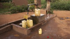
Collaboration between health and GIS specialists has improved, and the field has broadened from studying water-borne, vector-borne and other infectious diseases to addressing lifestyle, health promotion, mental health, well-being, non-communicable diseases, health systems, and policy.
The focus has shifted from basic mapping to understanding complex pathogen-host-environment dynamics, including modelling, forecasting, and preventing health risks.
Given its interdisciplinary and solution-oriented nature, geospatial health aligns well with current global health perspectives, such as One Health and Planetary Health.
Advances in remote sensing, AI, and ML are revolutionising how health data is collected, analysed, and used. High-resolution remote sensing and AI-powered medical imaging enable earlier diagnosis and health monitoring.
New data sources like crowd-sourced observations, social media, mobile phone data, and affordable geo-sensors provide real-time insights into environmental, chemical, and biological properties.
Platforms like the Global Health Observatory all follow FAIR principles, while open-access publishing makes data retrieval easier than before.
AI and ML improve health forecasting by detecting subtle patterns in large datasets, enhancing risk assessment. However, most ML tools are not yet 'spatially aware'.
The focus of geospatial health is shifting from response to anticipatory action. Traditional interventions often face delays due to political or logistical obstacles. Anticipatory action is based on predictive modelling and historical data to forecast and prevent disease outbreaks before they escalate.
AI and ML offer powerful tools for these forecasts, though the lack of accessible historical data limits their potential.
Making geospatial data more accessible and usable is essential. This can be facilitated by ensuring that data follows FAIR principles.
Maximising the impact of geospatial health research and practice requires free, global access to essential datasets, including historical and qualitative data like local knowledge and perceptions of health.
Engaging communities through participatory approaches ensures that research reflects their realities and can make policy recommendations more effective.
Innovative methods - combining climate and epidemiological data with AI and ML models, for example, are crucial for predicting health risks.
At the same time, better analytical tools and transparent 'glass box' models are needed to build trust and enable faster responses.
Collaboration between public health agencies and GIS scientists can be improved through shared research strategies and real-world case studies.
To achieve true global impact, it's crucial for high-income countries to build capacity and share technology with low-income countries, where disease burdens are highest.
Reinforcement of education in geospatial health will make it more likely that public health practice will later adopt geospatial approaches. Education in geospatial health should include spatial data science, especially spatial statistics.
Immersive and augmented reality should be integrated to provide a better understanding of models.
Researchers should engage health practitioners, policymakers, and funding organisations through accessible tools like geo-journalism, which combines interactive visualisations, StoryMaps, and infographics with clear, evidence-based narratives tailored to diverse audiences.
The past few decades have seen major progress in global health. People are living longer than ever before, maternal and child mortality rates are declining, new vaccines save countless lives, and some neglected tropical diseases have been eliminated.
However, challenges like urbanisation, rural poverty, infectious diseases, inadequate healthcare access, mass migration, and climate change persist. Addressing these challenges requires geographic perspectives and impact-driven research.
Geospatial health can substantially contribute towards achieving the UN’s Sustainable Development Goals (SDGs).
This story is an adaptation of a journal article: Amer, S., Augustijn, P. W. M., Anthonj, C., Tjaden, N. B., Blanford, J. I., van den Homberg, M. J. C., ... & Zurita-Milla, R. (2024). Geospatial Health: achievements, innovations, priorities. Geospatial health, 19(2), 1355. It has been adapted with permission from the authors and in accordance with the copyright license CC BY-NC 4.0.
To view the original article, see the link below: