
Artificial Intelligence
GeoVodcast #1: Spatial Inequalities in Deprived Urban Areas
34:21


Wherever people live and work near each other, it's important to have open spaces. Therefore we need to be sure that the share of open spaces in any built environment is sufficient at any given time. This type of accurate monitoring requires regular mapping. ITC researchers investigated an affordable method to achieve this.
Open spaces are defined as areas of land that are not built upon. They are important for livelihoods.
In urban surroundings especially, these spaces contribute to climate resilience, sustainability, safety, and general well-being.
Besides having various negative socioeconomic impacts, the absence of open spaces can lead to an increase in urban temperature and, as a result, a decrease in environmental quality.
People without sufficient open spaces can have an increased risk of obesity.
Open spaces are also important for emergencies, such as evacuation in the event of disasters.
For all these reasons, the United Nations' Sustainable Development Goal (SDG) #11 – specifically indicator 11.7 – focuses on the provision of open spaces for all.
However, the SDG database does not currently contain specific information about the share of open spaces within cities.
Furthermore, the mapping process is complex and the required data is often unavailable or unreliable. Creating reliable and workable maps comes with considerable financial costs.
To present a viable solution, the researchers developed a workflow that allows mapping from space, using satellite images to quantify the number of built-up areas relative to the green and grey open spaces. (Areas covered with vegetation, such as parks, are labelled green; areas without vegetation, such as squares and streets, are grey.)
Besides free-for-research images from the Planet platform, open data from OpenStreetMap and accessible official census data were used as additional input. Processing was done using Google Earth Engine's free-for-research cloud computational platform.
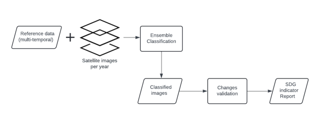
A diagram of the workflow.
The researchers tested their solution in the city of Kampala, Uganda. They carried out a multi-temporal study which provided training data from 2010, 2016, and 2018.
The workflow was applied to each dataset per year. The results show that from 2010 up to 2018 Kampala’s built-up area increased, to the detriment of the vegetation.
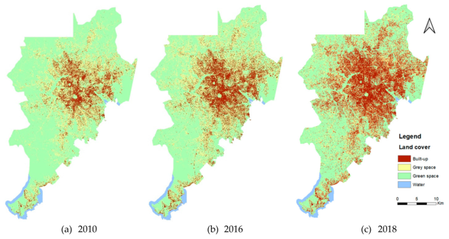
Kampala study area, 2010, 2016, 2018
The research addresses two issues.
The first is affordable access to data. The suggested workflow demonstrates that huge areas can be mapped for this particular purpose using free-for-research imagery, data, and cloud computation.
Second, the study shows the city dynamic and the way people keep losing vegetation, which underlines the need to develop built-up areas more sustainably.
All in all, the workflow proves that it's possible to operationalize SDG indicator 11.7 to map and monitor a full city.
As to future research and developments, efforts in this area will certainly be helped by the increasing amounts of data and computational power available.
What's needed now is the capacity to implement an infrastructure or system that can monitor more than just one city.
The ITC research is reproducible, so anyone interested can follow the workflow and produce similar results.
Finally, the researchers stress their belief that combining formal scientific data such as satellite images with informal volunteer data from sources like OpenStreetMap is the way forward for their science.