


Food Security
Is this the farm of tomorrow?
5 min
Identifying and mapping irrigation areas is critical for effective water resource management and food security. A recent study proposes a new method that's particularly suited for small-scale irrigation areas. The method was first applied in the Zamra catchment, a tributary of the Tekeze sub-basin in Ethiopia.
Ethiopia is focusing on expanding agricultural irrigation to improve livelihoods and achieve food security. The goal is to increase irrigated land and improve existing irrigation schemes.
In the study area, several types of water harvesting technologies are distinguished. Traditional water diversion schemes use simple, community-built structures. Modern diversion schemes are upgraded with concrete to address issues with traditional schemes. Earth dams store runoff during rainy seasons. Other schemes include check dams, wells, and springs, providing water during dry periods.
Under Ethiopia's Growth and Transformation Plan (GTP), irrigation development is classified based on the size of the command area: small-scale (less than 200 hectares), medium-scale (200 - 3000 hectares), and large-scale (greater than 3000 hectares). This study focuses on small-scale irrigation.

Type of irrigation schemes within the Zamra catchment. Mohammedshum et al. (2023)
The Zamra catchment has an area of 1588 km2, and the altitude varies from 1248 m to 3542 m above sea level. The topography is very complex, with mountains, plateau remnants, and steep escarpments with V-shaped and broad U-shaped valleys. The climate is mainly semi-arid, and the irrigation season runs from November to April.
Previous approaches to mapping irrigation areas include:
• Spectral reflectance mapping, using high-resolution satellite images to map irrigated areas.
• Remote sensing (RS) combining satellite imagery with rainfall time series to distinguish irrigated from rainfed areas.
• RS-derived products, such as FAO’s water deficit index (WDI), comparing rainfall and evapotranspiration data to identify irrigated areas.
All of these approaches present challenges, especially when it comes to mapping small-scale irrigation areas.
To overcome these challenges, the researchers present a novel approach in which multispectral time-series images with a very high spatial resolution are combined with digital elevation model (DEM) analysis and field knowledge.
In the study approach, expert knowledge thresholds for the NDVI-sum*, slope, drainage order, and distance maps are applied to identify suitable irrigation areas. The integration of multitemporal monthly NDVI analysis and topographic spatial expert decision rules, in conjunction with the utilisation of the random forest classifier algorithm*, facilitates the accurate delineation of small-scale irrigation areas.
The approach entails three steps:
1. Setting thresholds using expert knowledge to create samples using the NDVI-sum, slope, drainage order, and distance map.
2. Applying the random forest classifier algorithm to produce the classification map for different years.
3. Characterising the type of irrigation schemes and, eventually, the type of irrigation common in the area.
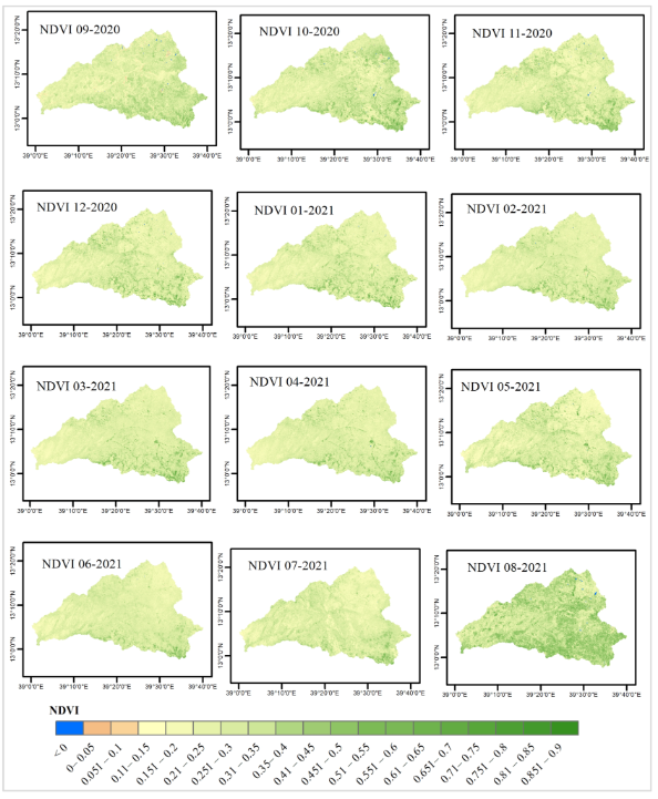
NDVI time-series map from September 2020 to August 2021. Mohammedshum et al. (2023)
To verify the accuracy of the proposed remote sensing classification, the researchers conducted a field survey during the irrigation season of 2020. Remotely sensed data used in the new method included Planet Scope imagery, base maps provided by NICFI (Norway’s International Climate and Forests Initiative), a digital elevation model (DEM) obtained from Copernicus GLO-30, and relevant precipitation data for the Zamra catchment.
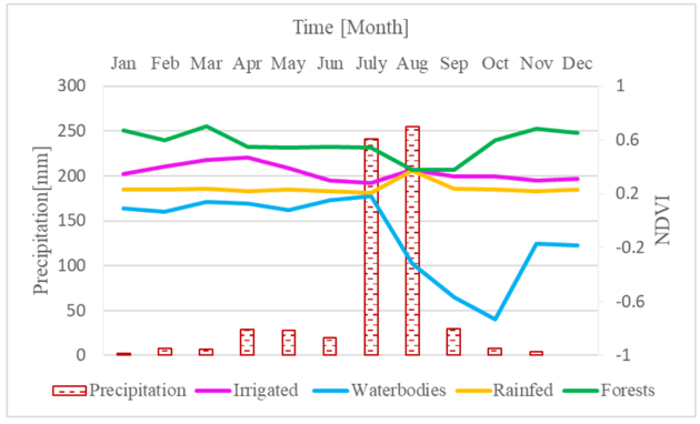
Average monthly precipitation and NDVI for different classes from September 2020 to August 2021 in the study area. Mohammedshum et al. (2023)
What truly sets this new method apart from previous approaches is the way expert knowledge is used in conjunction with a random forest classifier. The integration of expert knowledge allows for the inclusion of local insights and experience, enhancing the accuracy and reliability of the results. Moreover, expert knowledge can be combined with other relevant datasets to create a more comprehensive map of small-scale irrigation areas. It’s especially valuable when data is incomplete or insufficient.
The researchers surmise that their approach can be generally applied to extract small-scale and larger irrigation areas with similar agro-ecological characteristics elsewhere in Ethiopia. All it would take is context-appropriate expert knowledge-based thresholds for NDVI-sum, slope, drainage order, and distance.
Researchers also note that the better the expert knowledge representing the actual field situation, the better the outcome will be.
Interested to learn more? Geoversity offers a free 8-hour course titled ‘Exploration of Copernicus and Sentinel Data’. The course will familiarise you with the wealth of data residing in different online public and freely accessible repositories. In addition, it shows how to use cloud services to extract and process the data available.
The scope will be limited to a number of datasets that are of prime importance when conducting hydrological analysis, and the focus will be on retrieval of a (cloud free) satellite image from Sentinel 2, elevation and soils information, next to a time series of precipitation. Click here to register for the course.
Header image: Niels Van Iperen, CC BY-SA 4.0, via Wikimedia Commons
This story is an adaptation of a journal article: Mohammedshum, A. A., Maathuis, B. H., Mannaerts, C. M., & Teka, D. (2023). Mapping Small-Scale Irrigation Areas Using Expert Decision Rules and the Random Forest Classifier in Northern Ethiopia. Remote Sensing, 15(24), 5647. It has been adapted in accordance with the copyright license CC BY 4.0
To view the original article, follow the link below:
Login and start learning!
